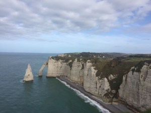
It’s no accident that the white cliffs of Dover are on the other side of the English Channel from Etretat. You will see that these cliffs were the subject of the Impressionists. The crescent shaped bay with fairly calm water once made it a thriving fishing village and ultimately a popular seaside resort (again only a train ride away from Paris) in the 19th century. For the Impressionists having subject matter for Plein Air painting (outside on the site) was one thing that drew them, the amazing light which we understand living on the coast as we do, but also the Impressionists were interested in depicting leisure time. This is the perfect setting for that. Now there is no longer a port except for rental boats so the streets are lined with restaurants, hotels, and knick knack shops but all that does not detract from the natural beauty.
Not damaged in World War II there are some 18th and 19th century buildings intermixed with the more contemporary architecture
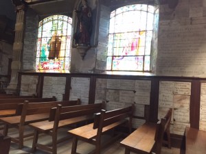
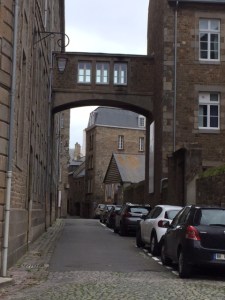
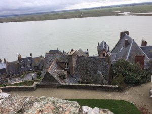
Central area of Etretat
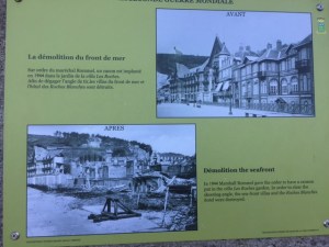
Photo of the seashore before the war and how the Germans destroyed the seaside buildings to set up their tank barricades and large guns
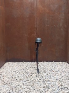
German bunker left from World War II
Most of the fishing boats have been saved as thatch covered boat rental huts
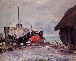
Monet, “Fishing Boats at Etretat”, 1873
Looking south
Monet, “Etretat”, 1883
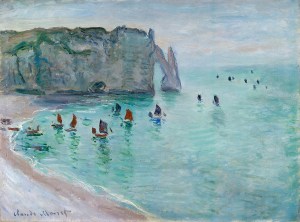
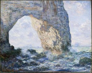
Monet, “Cliff of Aval”, 1885
Sun and sea combine to create amazing light
Monet, “Etretat, Cliff of Aval”, 1885
View to the north from top of the cliffs.
View to the north from path along top of cliffs
Monet, “La Manneporte”, 1883
Tide can get low enough for people to walk through the arch on intensely pebbled beach. Wasn’t that way when we were there and there are also signs asking people not to take pebbles from the beach.
We are no longer in France but due to several intensive travel days I got behind so I’ll be sharing France with you a few days longer. Honfleur is best known as a mecca for the Impressionist painters in the late 19th century because of it’s expansive landscape, the coastal light and the easy travel by train from Paris. Even today Parisians flock to Normandy to “get away.” For some reason this picturesque town was spared destruction during World War II and it is quintessentially cute though not in a bad way. In fact it seems to be spared the chain stores, at least in the compact downtown (compact in that to drive the streets you have to put both mirrors in and someone has to direct walking ahead of the car).
Honfleur is still a port thought mostly it appears to be large sailboats and tour boats, with a few fishing boats mixed in. Le Havre, the large port to the north (and quite industrial) has long eclipsed Honfleur. This is where the Seine River meets the English Channel. William the Conquerer received supplied from Honfleur once he had invaded England and Samuel de Champlain sailed from here in 1608 to North America, where he explored the St. Lawrence River and founded Quebec City. But of everything, artists like Monet might be said to have launched modernism from here.
“Impression Sunrise”, Claude Monet, 1873
This is probably Monet’s most iconic painting and got its name as a derogatory response from a critic who said it was just an “impression”. Monet liked that idea and the movement was born! I did not know this painting was painted close to Le Havre.
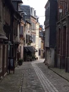
The narrow alleys of Honfleur
“Rue de la Bavolle”, Monet, 1864
One of the wider streets leading to the Eugene Boudin Museum. Didn’t think there was such a thing as a museum not worth visiting but this was one. Too bad for a place that inspired so many.
In the center of town is the clock and bell tower of St. Catherine’s Church. It was built detached from the church so as not to put much stress on the building and to minimize fire danger.
“Bell Tower of St. Catherines”, Monet
First built in 1466 and added to in 1497, looks like an upside down boat (makes sense with lots of boat builders and no cathedral architects around).
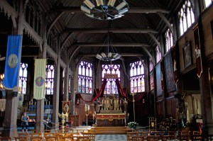
Interior of St. Catherines, lovely simple structure though the fluorescent chandeliers were a bit of a turn off.
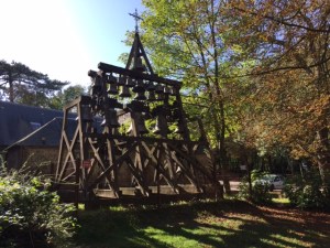
Highest point around is a tiny chapel called Cote de Grace, built in the early 1600s.
Since the chapel is so small the church bells are outside. The bells still ring every 15 minutes.
The interior of the chapel is filled with plaques left by pilgrims seeking help.
Nautical theme inside the chapel.
Le Havre looking across the Seine from the Cote de Grace. Although it looks very different today, this is the port from which my mother sailed to Canada after the war as did my father (same boat), he returning from fighting in Israel for independence from Britain.
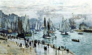
“Fishing Boats Leaving Le Havre”, Monet, 1874
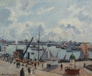
“Pilots Jetty, Le Havre”, Camille Pissarro, 1903
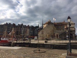
The harbor in Honfleur is closed in on three sides.
The tall skinny buildings that now house hotels and restaurants were once fishermen’ houses and designed at a time when buildings were tied based on their width, not height.
“La Maria (The Harbor)”, Georges Seurat, 1886
The Lieutenancy marks the entrance to the harbor and was used Napoleon’s governor as his home.
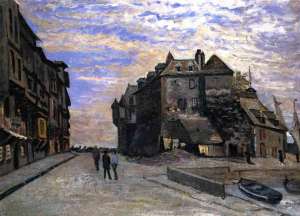
“The Lieutenancy”, Monet, 1864
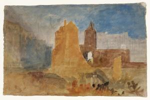
“The Lieutenancy Building at Honfleur, Normandy” Joseph Mallord William Turner, 1832
If you haven’t read the book “All the Light You Cannot See” I highly recommend it. It is supposed to have taken place in Sant Malo so we made a little excursion there. It’s not far from Sant Michel and like it is very close to the water though not an island. The walled old city was established in Roman times so it has a long history. In World War II (the time of the novel) the ancient city was virtually destroyed by American and British fire. The Allies believed that Sant Malo was a Nazi stronghold when it turned out there were only about 100 German soldiers there. It was interesting walking around in a space you only know from your imagination, and I have to say my impression was pretty good so an even better reason to read a novel well told. I’m just going to publish a gallery of photos with no captions as I really didn’t learn a lot about the town as we walked.
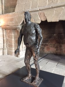
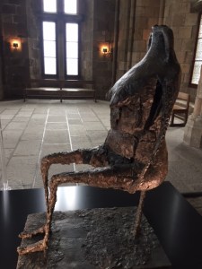
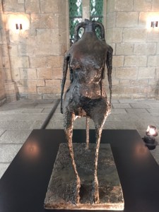
It was interesting to see the work of a 20th century artist exhibited within the walls of the abbey. The artist, Germaine Richier, 1902-1959 was a French artist who worked in bronze and whose work reminds me of Picasso’s bronze sculptures as well as the work of Modigliani. The work looks very interesting against a stone background. She received a classical training at the Beaux Arts in Montpellier. She was very affected by World War II and her work has an expressive as well as tragic dimension. The Pompidou Center in Paris is partnering with national monuments to pay tribute to this particular important French artist of the 20th century. It’s nice to see.
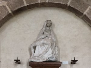
This pieta has the head of Jesus smashed off, probably during the French Revolution.
Male figure entitled “L’Orage”, appears to be as if petrified (like figures discovered at Pompei). The artist visited there in 1935.
The female double entitled “L’Oragane”. This and the male counterpart were created in 1948-49.
This was my favorite piece, composed from the neck of an ancient Greek amphora found on a beach.
Title of the work is “L’Eau” (water), 1953.
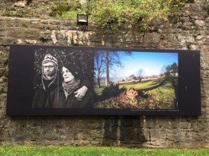
Once again at the visitor center for Mont Sant Michel were these billboard sized photographs of people who live in this part of Normandy
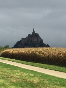
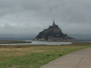
Mont Saint Michel is one of the most photographed sites in France and gets more than 13 million visitors a year. It rises atop a very small island at the tip of Normandy and as you might expect there’s a bit of a rivalry between Normandy and Brittany over who it belongs to. It is one of the four most visited religious sites in Christianity though mostly tourists outnumber the pilgrims these days. In 708 Bishop Aubert of Avranches, is said to have had three visions in which the angel Michael commanded him to build an oratory on Mount Tome the closest island to the town. The first two times the bishop ignored him so the angel poked him in the head leaving a dent. Aubert built a small church on the island which rapidly became a pilgrimage site for followers of the angel Michael that had been active since the 5th century.
Mont Saint Michel is surrounded by a mudflat and the tidal change along the coast is big so for periods of time it’s possible to “walk” out to the island. In 1878 a causeway was built that allowed pilgrims to come and go regardless of the tide. It increased the flow of visitors but blocked the flow of water around the island. The result was that much of the bay silted up and the island was rapidly becoming part of the mainland. The original purpose of providing a haven for monks and its uniqueness was disappearing. In a major engineering and environmental project French engineers with help from their Swiss and Dutch counterparts began a massive reclamation project building a dam upstream on the river to collect water during high tide and flush out the bay at strategic times and a bridge was built to replace the causeway which had been solid.
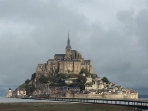
The visitor center and massive parking lots have been moved away from the site so now you can make the journey on food or by shuttle. Approaching it slowly makes it all the more magical especially on a day with dramatic weather.
As you approach you can see the river emptying into the bay.
The new bridge approach that replaced the causeway. The island has three sections, ramparts at the bottom that encircle the island, the village (population 30 with mostly shops and restaurants, topped by the abbey.
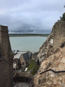
Mudflats appearing below the ramparts.
The village has existed since this became an active pilgrimage site so one can imagine that the tourists you see today were coming for a different purpose in the Middle Ages. It’s possible to avoid the shows by climbing up stairs to get to the abbey on top.
Entrance to the village
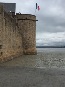
Cannon is probably left from French Revolution when this served as a prison.
The winding stairs take you directly up to the abbey.
Looking down a mixture of old and new
Looking at the village from above and behind, much more attractive.
Pilgrims and tourists wend their way up as we wend our way down.
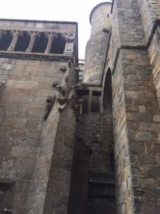
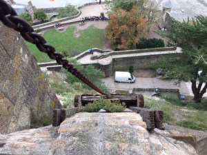
In the next set of images you’ll see how the Abbey took shape over many years adding different functions and styles. This is how they got supplies into the Abbey.
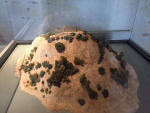
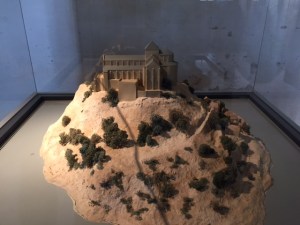
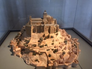
The abbey has been here for 1200 years and for most of that time home to Benedictine monks. Much of the history was lost when its archives were taken to St. Lo for safety during World War II and were destroyed during the D-Day fighting. These models and reconstruction of the tower models give you a good idea of the architectural development.
10th century with small Romanesque church on top of the island and nothing else.
11th and 12th century development with a village starting below the abbey.
17th and 18th centuries including the ramparts
20th century
interior structure of the tower and cupola
putting the new cupola in place with helicopter
A word about Saint Michael; a warrior saint clad in armor, is often seen slaying a dragon (symbol of the Devil) with his sword. In his other hand he carries a set of scales. In the Middle Ages it was believed he weighed the souls on Judgment Day so if you wanted to get in his good graces you might have considered a pilgrimage to Saint Michel.
On the way up it’s easy to see the various styles here especially the more recent Gothic Flamboyant style.d
Not a particularly beautiful relief sculpture but shows the Angel Michael poking the bishop in the head.
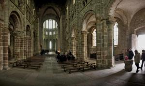
The interior of the abbey church itself. The newer addition can be seen through the nave. Since Medieval churches had wooden roofs fires often meant rebuilding and depending on the style at the time of reconstruction many styles are integrated.
Monks have to eat and this is the refectory (good way to see the wooden ceiling) and lots of light coming in. Picture all silent monks with one of them reading from the bible in a monotone voice.
The windows are set high and recessed so they let in light but did not allow the monks to look out.
Repairing the cloisters- pink marble columns that have seen age and weather (sea air)- cleaning and painting.
This is called the crypt and it’s a room full of massive columns that hold up what is above. Those Romans who improved on the column and added arches really knew what they were doing.
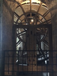
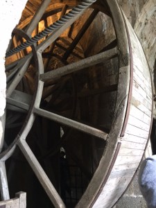
This is called a treadwheel and was introduced during the French Revolution when Saint Michel was used as a prison. It’s how they brought up supplies.
Close up of the treadwheel shows that three prisoners at a time were put into this device (hamster like) to move it so the pulley could bring up supplies.
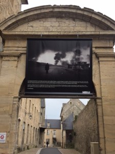
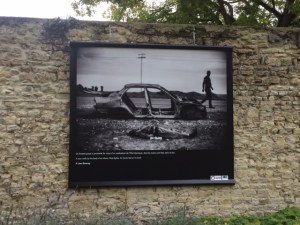
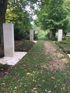
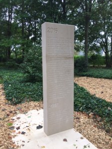
In a place that is at peace after suffering so much for centuries, it’s important to remember that in other places things are not so peaceful. Throughout Bayeux right now there is a photo exhibition of large billboard sized photographic panels of photographs from the conflict to liberate Mosul, Iraq. It’s a reminder to all of us what war continues to do. We also visited the Memorial to the Reporters that is in a beautiful garden setting, that lists the names of all reporters who have lost their lives from 1944 to the present. The plaque at the entrance says: This place is dedicated to reporters and to freedom of the press. It is unique in Europe, firing a walkway among white stones engraved with the name of journalists killed all over the world since 1944. This project by the town of Bayeux and the organization Reporters Without Borders was inaugurated in 2007 by Rama Yade, Junior Minster for Human Rights and Patrick Gomont, mayor of Bayeux.
It goes on to say on another plaque: Bayeux, which witnessed a freedom dearly won, has included the Memorial to Reporters to encourage the younger generations to think about what freedom really means. “We must uphold freedom of speech, it is the basis for all other freedoms, it is how we enlighten each other.” Voltaire.
Near the gallery of the Bayeux Tapestry is the start of the photography series documenting Mosul, Iraq.
An IS fighter lies dead next to a burned out car.
Refugees from Mosul.
Iraqi soldier puts his boot on the chest of dead IS fighter.
Shepherd outside Mosul with his oil blackened sheep.
Few in the 1950s and the names are mostly Eastern European and some Asian
Vietnam years, some Europeans and Americans, mostly Vietnamese reporters.
This year almost all of one side and half of the back side, almost all Arabic names.
We can hope that someday the only tanks we see are the ones parked in front of museums.
We visited Omaha Beach and the American cemetery, the site of the D-Day landings on a gloomy and drizzly day. It seemed appropriate for the experience. Before coming here it didn’t really hit me how many young people gave up their own futures so that we could have one, and went off to a place where they knew no one thousands of miles from their own homes that at that time were not actually threatened. At the same time I’m thinking about the fires close to our home and just a tiny taste of what it might feel like to be endangered. The people of Europe were suffering immeasurably and Americans helped relieve their suffering.
The artist of “The Braves” wrote: I created this sculpture to honor the courage of these men: sons, husbands, fathers, who endangered and often sacrificed their lives in the hope of freeing the French people.The Wings of Hope so that the spirit which carried these men on June 6, 1944 continues to inspire us, reminding us that together it is always possible to change the future. So that the example of those who rose against barbarity, helps us remain standing strong against all forms of inhumanity. So that this surge of brotherhood always reminds us of our responsibility towards others as well as ourselves. On June 6, 1944 these men were more than soldiers, they were our brothers.
I’m struck by what war has meant for this part of the world. William the Conquerer started 400 years of bloody conflict with Britain.
At the Visitor Center at the American Cemetery
Anitore Banon, “The Braves”, installed 2004
close up of sculpture
Looking up from the beach it looks quite benign but imagine coming off the beach with no cover and having to scale those hills from which Germans were shooting down on them. Many people died before getting off the beach.
A model showing the landing
The cemetery is now on top of the hill they scaled to move on to Bayeux, the first town liberated.
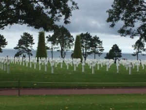
Rows and rows, it’s very peaceful up here on top of that hill.
There are 9000 buried here, those whose families preferred them to be buried with their comrades rather than be brought home.
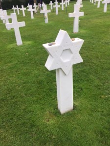
The Jewish graves have stones which is a traditional marker when one visits a Jewish grave. We placed stones on some of the ones that didn’t have them though stones were hard to find in such an immaculate site.
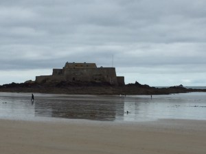
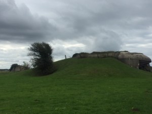
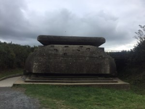
Four German casements built to guard against seaborne attacks were part of 15,000 that stretched from Norway to the Pyrenees.
These are the only ones remaining and they could hit targets up to 12 miles away.
They were so well camouflaged that attempts to destroy them were difficult though they eventually were.
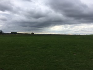
Just imagine the terrain that soldiers had to traverse on their way inland.
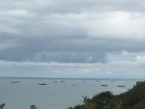
This communication lookout was a few hundred yards closer to the water and sent relays back to the guns by wire.
From around the bend of the lookout you can look north and see the remains of Winston Harbor. So you can imagine they had to take out those guns.
A Russian cannon from World War I that the Germans were also using. Looks like a toy compared to the large gun.
As you drive through the countryside there are these poster sized photographs showing “then” and this is now. The British built bypass roads so they would avoid the little villages and these are the main roads through this area now. These posters are a reminder to all of us. The people of this region don’t need reminders but do so anyway.
Arromanches, a small town on the coast was ground zero for the D-Day invasion in World War II. Since it’s only 20 miles from Britain, the Allies decided it would be easier to build their own port than try to capture one from the Nazis. So practically overnight this tiny village that had been a fishing village and then turned into a resort in the 19th century became a huge port, Port Winston that gave the Allies a place to supply the troops who would be coming on shore a few miles away. If you think about 2.5 million soldiers invading, they would need a lot of supplies. Port Winston allowed the Allies to begin their ultimate push to Berlin and the end of World War II. So the day after the invasion started, this is how they did it 17 old ships sailed across the English Channel and were sunk so that each bow face the next ship’s stern, forming a sea barrier. The 500 tugboats towed 115 football field sized cement blocks across the Channel and these were also sunk, creating a 4 mile long breakwater 1.5 miles offshore. Then pontoon bridges that were manufactured in Britain were set in place so that they moved with the tides and currents. 115 anti-aircraft guns were installed on the bridges and cement blocks to protect a port the size of Dover, the world’s busiest passenger port today.
Eleven months later Hitler was dead. I had never heard about any of this, and it’s amazing the engineering and will power that went into making this whole thing a reality. Yes, things had gotten to a turning point for the Allies (more about that in the next posting) though it always amazes me the gaps in my knowledge, especially when WWII is so close to my own experience. If it was not for these brave people who sacrificed so much I would not be here.
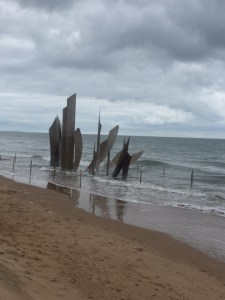
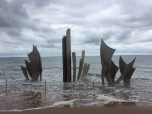
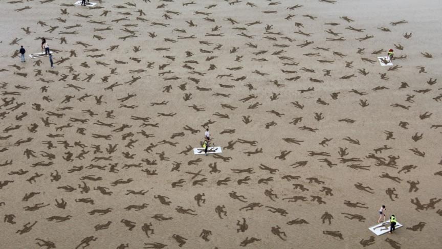
Aerial view of Port Winston at the time of it’s completion. It was in operation 6 days after it was started. Decoy aircraft were aloft over the port to fool the Germans.One of the concrete barriers nearing completion in Britain prior to its installation.Across these bridges, 54,000 vehicles, 326,000 troops, and 110,000 lbs. of supplies were ferried from Britain to France.At the museum you can see a section of the pontoon bridge.A model of one of the concrete breakwater sections towed into place.Looking south you can see the formidable cliffs the soldiers had to climb and in the distance two of the concrete breakwater pieces still in place.Unloading supplies from a shipRemains of one of the bridge sections still in the water and in the distance a piece of the breakwater.Looking back to the village one can imagine how the people felt at that time (or if they were even still there by the time the Allies came ashore). Not much is said about the people of Arromanches at the time but it looks like many had fled or were in hiding.Model showing the pontoon bridge and the display included moving water so you could see how it all moved with the tides and currents.A sand installation on Arromanches Beach by “Sand in Your Eye” to commemorate the 9000 who lost their lives here, entitled “The Fallen”, 2013. It was soon washed away.
My bucket list mostly consists of works of art I have been fascinated with and have only seen in reproduction. Seeing them in the place where “they live” is an amazing experience for me. One such work is the Bayeux Tapestry, not actually a tapestry at all, an embroidery that is 20″ tall, 250 ‘ long and was created in the year 1066. It’s in remarkable condition considering that it was used as a tarp during the french Revolution over a truck full of weapons, was rolled around a cylinder in the 19th century and the creases left from that can still be seen, and as did the city of Bayeux itself survived World War I and II. It tells the story of the Norman Conquest of William who vanquished Harold at the Battle of Hastings and launched 400 years of war between Britain and France. There are some who say, had this not happened Britain would have remained isolated from the rest of Europe as Scandinavia is today. Looks like Britain might be going that way again.
Getting back to the tapestry it’s displayed in a safe environment now and as you walk along you hear the story that is told in exquisite detail. Period music is played as the narrator speaks. Here are a few excerpts from the tapestry.
These are the ships that William used to sail to Britain, he had to wait a long time for favorable winds in the Channel. To scale model of a Viking boat similar to the ones used by William in the museum upstairs.Harold comes to Normandy to tell William that he will be king when Edward dies and he swears allegiance on two of Normandy’s most important reliquaries.Edward dies and Harold has himself crowned, against his promise to William to acknowledge him as king.Haley’s Comet is seen in the sky, a bad omen for the futureYou can see the servants carrying the suits of chain mail (on the left) in preparation for the battleChain mail suit.This is one of the most dramatic scenes, William’s army advancing and they look invincible. Look at how this shows the horses as three dimensional figures and advancing towards the enemy. It’s almost like a flip book.Westminster Cathedral as it looked in William the Conqueror’s day (model of what he had built)Cathedral todayTower of London, built by William the ConquerorTower of London today
Hard to believe as always that we arrived in Paris less than 24 hours ago and have already done and seen quite a bit. We took the train this morning to Bayeux in Normandy to begin a week’s adventure in this part of France. We departed from the St. Lazare train station, the same one made famous by Claude Monet who painted the steam engine trains arriving at this station because it was the station he used to come and go to Giverny, his home along the Seine in the direction of Normandy. He also painted on the coast here (more about that later in the week). Monet was particularly enamored with the steam engine because it fit in with his desire to paint en plein air (out in the air “on site”) and to capture a moment in time. As you can see the station has changed quite a bit since Monet’s time.
St. Lazare Station, Paris, 2017
Claude Monet, La Gare St. Lazare, 1877, oil on canvas
Art installation, Gare St. Lazare, 2017
Staying in a converted chateau built at the end of the 18th century as an extension of a manor house from the 15th century. During WWII it served as a headquarters for British troops (more on this to come) and housed 100 soldiers. Earlier this week our Modern Art class learned about the Palace at Versailles, which started out as a chateau. This one is very much in the style of Giverny, Monet’s home.
Monet’s Chateau, GivernyChateau de Bellefontaine, Bayeux
Bayeux is a Medieval town near the coast of Normandy that is best known for the Bayeux Tapestry (more on that tomorrow). The town was established by the Romans in the 1st Century BCE, was destroyed by the Vikings in the 9th century, rebuilt, and pillaged continuously until the early 15th century. If you look at the map of France this region is an easy access point from Britain or further north which gives it such a rich and painful history. Amazingly it was not destroyed during either World War. In fact, it was the first city liberated but the Allies in World War II.
Aure River flows through the heart of BayeuxMany preserved buildings from the Middle AgesBayeux Cathedral in the background